Sailboat Navigation: How to Navigate on Water
Mastering sailboat navigation is of paramount importance for sailors of all levels of experience. Whether you’re a seasoned sailor or a novice setting out on your first boating adventure, having a solid understanding of marine navigation is essential for your safety and confidence on the open waters. By honing your navigational skills, you can ensure that you navigate waterways with ease and make informed decisions to avoid potential hazards.
In this guide to sailboat navigation, we will delve into the intricacies of navigating a boat. Whether you prefer electronic or traditional methods, we will cover them both. We will explore electronic navigation techniques, including the use of GPS systems and chartplotters, which provide real-time information and streamline your navigation process. Additionally, we will delve into traditional navigation methods, equipping you with the necessary skills to navigate using natural references such as compasses, charts, parallel rulers, and dividers.
The Art of Sailboat Navigation
Navigating a boat is a unique skill that differs significantly from driving a vehicle on land. Unlike roads and signs, the waterways present a dynamic environment with minimal navigational markers, and visibility can be limited due to fog or the absence of recognizable landmarks. Becoming a proficient marine navigator requires years of accumulated knowledge and advanced learning. However, with a solid understanding of the basics, navigating most inland and nearshore waterways under normal weather conditions becomes a manageable task. Let’s break it down into simple steps.
Electronic Navigation
Electronic navigation has revolutionized the way boaters navigate the waters. With advancements in technology, electronic navigation systems have become remarkably user-friendly, making them a popular choice among boaters. The benefits of electronic navigation include:
You can find some helpful tips about GPS Navigation here!
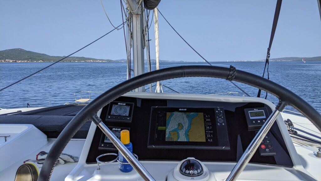
Operating GPS or Chartplotter
To make the most of electronic navigation, it’s crucial to familiarize yourself with the features and operation of your GPS or chartplotter. Here’s a general overview of operating these devices:
Creating Waypoints and Route Planning
Waypoints are specific locations on your navigation route that serve as markers for your journey. To create waypoints on your chartplotter:
Route planning involves connecting multiple waypoints to create a planned course. This allows you to chart a path that aligns with your intended destination or desired route. Some advanced chartplotters even offer autopilot capabilities, enabling your boat to follow the planned route automatically.
Following the Route and Chart Considerations
Once your route is established, your chartplotter will provide you with guidance on following the course. The device will display a compass course to steer, directing you toward each waypoint. It’s important to refer to the steering screen on your chartplotter, which shows both the desired compass course and your current heading.
While electronic navigation offers convenience and accuracy, it’s essential to exercise caution and consider chart considerations. Study the chart carefully, paying attention to potential obstructions such as landmasses, restricted areas, or shallow waters that could pose risks to your boat. It’s advisable to have backup plans and be aware of the limitations of your electronic devices. Remember, electronic navigation should be used in conjunction with other navigational tools and techniques for a comprehensive and reliable approach to marine navigation.
Traditional Navigation
While electronic navigation has become increasingly popular, traditional navigation methods still hold significant importance, especially as a backup when electronic devices malfunction or lose power. It’s essential to have a solid foundation in traditional navigation techniques, as they provide valuable skills and knowledge that can save the day in unexpected situations. By familiarizing yourself with traditional navigation, you can navigate effectively using natural references and maintain your course even when modern technology fails.

Compass
The compass is a fundamental tool for determining the direction in which your boat is heading. It provides readings in degrees relative to magnetic north and serves as a reliable reference point during navigation. By referencing the compass, you can steer your boat accurately along a chosen bearing, ensuring you stay on course even without electronic assistance.
Charts
Charts are detailed maps specifically designed for waterways. They contain crucial information such as water depths, channel markers, lighthouses, and restricted areas. Obtaining and utilizing charts for your intended routes is vital for traditional navigation. You can purchase printed versions or access online resources that provide free digital charts. Understanding how to interpret charts and extract pertinent information is essential for safe and effective navigation.
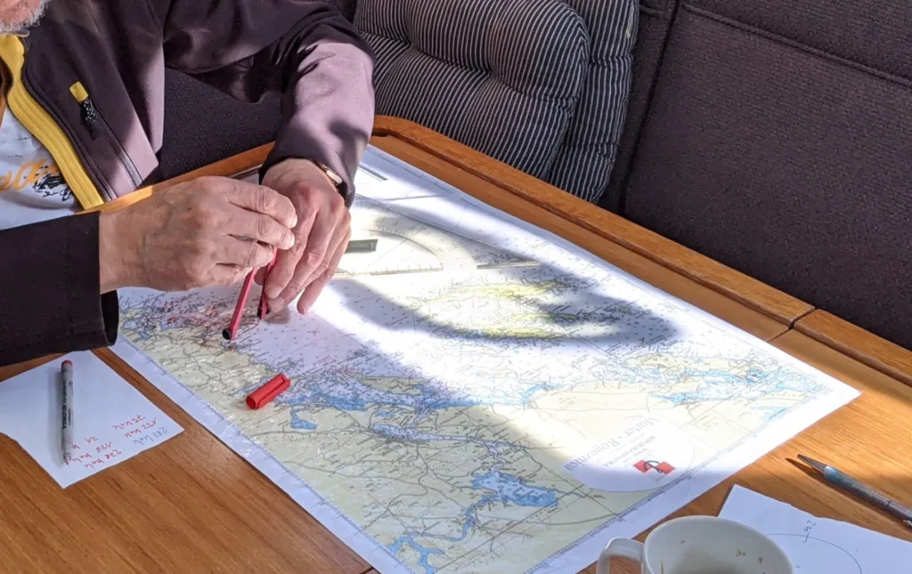
Parallel Rulers
Parallel rulers are invaluable tools used in traditional navigation to determine the exact compass bearing of a course you wish to steer. These rulers consist of two straight edges joined by adjustable knobs. By “walking” the rulers across the chart, you can align them with the compass rose, providing you with the desired bearing. Parallel rulers allow for accurate and precise course plotting, helping you navigate along your intended route.
Dividers
Dividers, also known as navigation dividers, are essential tools for measuring distances on a chart accurately. These tools consist of two hinged arms with pointed ends that can be adjusted to the desired width. By adjusting the dividers according to the chart’s scale, you can determine the distance between two points with precision. The chart’s key will provide the necessary scale information in miles or nautical miles. Dividers help you measure distances along your planned route, ensuring you maintain accurate positioning throughout your journey.
By utilizing the compass, charts, parallel rulers, and dividers, you can navigate using traditional methods and rely on these tools as backups or primary navigation techniques when needed. Traditional navigation provides a solid foundation for understanding the principles of navigation and is an essential skill for all boaters, complementing and enhancing electronic navigation systems. It ensures you have the knowledge and capabilities to navigate safely and confidently, regardless of technological advancements.
Basic Navigational Tasks
Determining Your Boat’s Location
To navigate effectively, it’s crucial to determine your boat’s location on the water. Here’s how you can ascertain your boat’s position using navigational aids:
By using this triangulation method, you can determine your boat’s location with a reasonable degree of accuracy, even without electronic navigation devices.
Navigating to Your Destination
Once you know your current location and have identified your desired destination, it’s time to chart a course and navigate towards it:
Following Your Course
Maintaining a steady course is essential during navigation. Here’s how you can follow your course effectively:
By diligently monitoring your boat’s compass, making necessary adjustments, and utilizing navigational aids, you can successfully follow your course and reach your destination safely and efficiently.
Remember, mastering basic navigational tasks is essential for any boater. These tasks form the foundation of marine navigation and allow you to confidently explore the open waters while maintaining a clear sense of direction and control over your boat.
Embracing Technology for Enhanced Navigation
Radar Systems
Radar systems offer a valuable technological advancement in marine navigation, providing real-time information about your surroundings. Here’s what you need to know about radar systems:
While radar systems are incredibly beneficial, it’s important to understand their limitations and use them in conjunction with other navigation methods for a comprehensive approach to marine navigation.
Autopilot Systems
Autopilot systems offer convenience and assistance by relieving you of the constant task of manually steering the boat. Here are key aspects of autopilot systems:
Nautical Mobile Apps
Nautical mobile apps offer a wide range of features to assist boaters with navigation. Here are the benefits and some cautionary notes regarding the use of these apps:
By embracing technology in marine navigation, you can enhance your overall boating experience and improve your navigational capabilities. Radar systems, autopilot systems, and nautical mobile apps offer valuable tools and information that, when used appropriately, can increase your situational awareness, streamline your navigation process, and help you navigate safely and efficiently. However, always remember to complement technology with traditional navigation skills and remain vigilant to ensure a comprehensive and reliable approach to marine navigation.
Conclusion
Mastering sailboat navigation is a critical skill for boaters. In conclusion, mastering marine navigation is a continuous journey of learning and practice. By combining the knowledge and skills presented in this guide with hands-on experience, you can become a proficient navigator, ensuring your safety and enabling you to explore the open waters with confidence.
So, set sail, embrace the art of marine navigation, and enjoy the exhilarating adventures that await you on your boating journeys. Fair winds and safe travels!